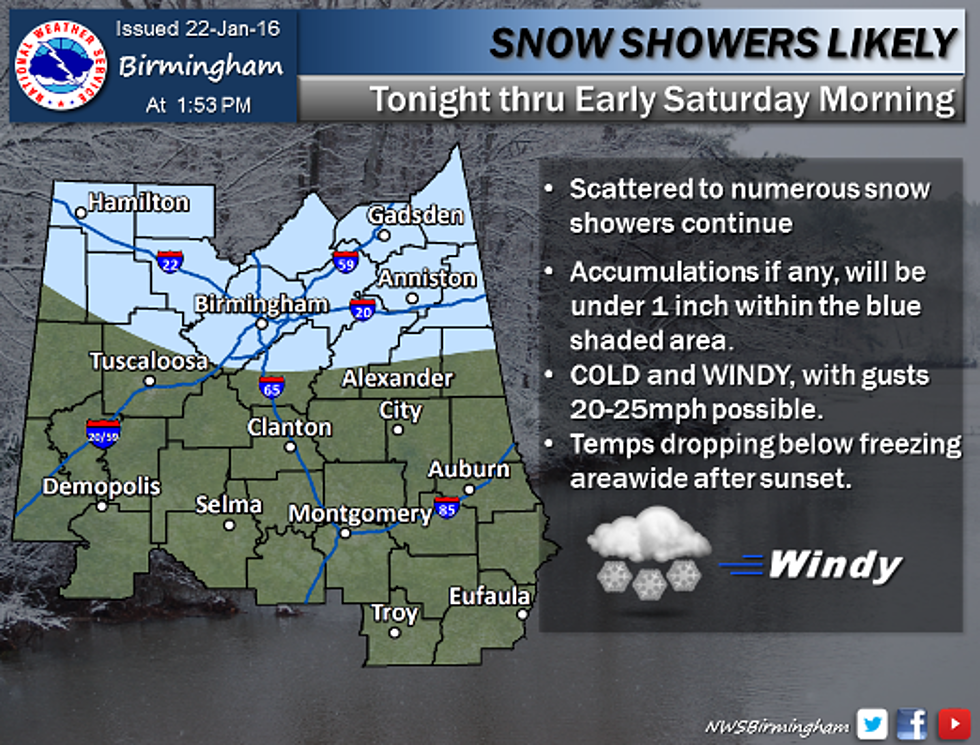
When and What to Expect: Winter Weather Forecast Update for West Alabama
Snow showers, gusty winds, icy travel, and freezing temps are all in the weather mix for West Alabama, we help sort out what to expect and when.
The Advisories:
Winter Weather Advisory until 9 a.m. on Saturday, January 23 (this advisory may be lifted early by the weather service). This advisory means there is potential for periods of snow which may cause travel difficulties.
Wind Advisory until 11:59 p.m. on Friday, January 22. This advisory means wind gusts of 25 to 30 mph are possible. These strong wind gusts may make traveling difficult, especially for high profile vehicles.
When and What to Expect:
Tonight:
- Snow may continue to mix in with rain through late evening.
- Temperatures remain steady at 34 degrees. Tuscaloosa County should remain above freezing until around 8:00 PM.
- No travel issues expected through this evening.
- Most precipitation should exit Tuscaloosa County after 10 PM tonight. We won’t have long below freezing until precipitation stops.
- If any, accumulations will be minor (less than half an inch), in the northern portion of Tuscaloosa County.
- Overnight, some elevated areas could become slick as temperatures drop below freezing.
Saturday:
- Saturday morning should be free of precipitation but will remain windy with gusts to 30 mph.
- Temperatures will not transition above freezing until late-morning Saturday.
- Spotty icy travel conditions, especially on bridges and elevated roadways, could exist through mid-morning.
- Mostly cloudy Saturday morning, then gradually becoming sunny by afternoon, with a high near 39. Northwest wind 10 to 15 mph.
More From Praise 93.3


![Significant Risk for Severe Storms Across Alabama Today [VIDEO]](http://townsquare.media/site/530/files/2016/02/new-wx.png?w=980&q=75)
