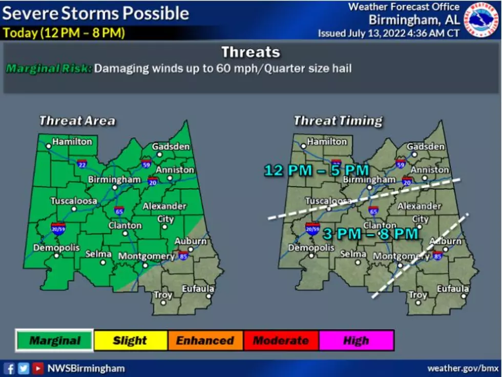
Slight, Marginal Risk of Severe Thunderstorms for Most of Alabama Today
Tropics Update
Regardless of the development of the tropical disturbance near the Gulf Coast, there is the possibility of heavy rainfall. The National Hurricane Center has predicted that the “formation chance through the 48 hours is low and near 0 percent. Formation chance through 5 days is low and near 0 percent.
According to the Weather Channel, “an area of disturbed weather in the northern Gulf of Mexico is unlikely to become a tropical depression, but it still poses threats of heavy rainfall, lightning, and rip currents.”

Storm Prediction Center Outlook
The Storm Prediction Center has most of Alabama under a “marginal risk” of severe thunderstorms.
What to Expect
James Spann, ABC 33/40, and Townsquare Media Tuscaloosa Chief Meteorologist said that our area can “expect scattered to numerous showers and thunderstorms today statewide as moisture surges northward from the south, and a weak surface front approaches from the north.”
Wednesday Timing
“The most widespread rain will come during the afternoon and evening hours... the high for most places will be in the upper 80s with a limited amount of sun,” said Spann.
Possible Impacts
The National Weather Service in Birmingham notes that a “few strong to severe thunderstorms are possible this afternoon and evening with damaging wind gusts and hail the primary threats. Showers and thunderstorms could produce locally heavy rainfall this afternoon and evening, particularly along the interstate 20 and 59 corridors. Flooding of low-lying or poor drainage areas may result.
Where:
All of Central Alabama has a threat of localized flooding, with severe threats generally north & west of a line from Montgomery to Auburn.
When:
Today through Tonight (12 pm to 8 pm)
Threats:
Localized flooding, especially in poor drainage and low-lying areas
Isolated damaging winds to 60mph
Quarter size hail
(Source) Click here to follow the Facebook Page for James Spann. For more from the National Weather Service Birmingham, click here. To get more information from the National Hurricane Center, click here. For additional information from The Weather Channel, click here. For more insight from the Storm Prediction Center, click here.
LOOK: The most expensive weather and climate disasters in recent decades
KEEP READING: Get answers to 51 of the most frequently asked weather questions...
LOOK: The most extreme temperatures in the history of every state
More From Praise 93.3