Hazardous Weather Outlook For Today
Current Weather Information:
The Hazardous Weather Outlook continues for our Townsquare Media listening areas, there is the possibility of severe thunderstorms thru 7 pm for the southern half of central Alabama. The main concerns are still damaging winds up to 60 mph and large hail.
Expired Weather Information:
Heads up for Sumter County, there is a significant weather advisory until 4:45 pm for Southwestern Sumter. You could experience winds in excess of 40 mph.
Some counties were canceled early for this > Severe Thunderstorm Watch until 7 pm for many of our Townsquare Media Listening Areas. Counties Include: Autauga, Bibb, Blount, Bullock, Calhoun, Chilton, Clay, Coosa, Dallas, Elmore, Fayette, Greene, Hale, Jefferson, Lamar, Lowndes, Macon, Marengo, Montgomery, Perry, Pickens, Shelby, St. Clair, Sumter Talladega, Tallapoosa, Tuscaloosa, and Walker.
There is a Significant Weather Advisory until 345 pm for Southern Greene, Southern, Hale, East Central & Western Perry, & Sumter w/potential for winds in excess of 40 mph, heavy rain, & lighting.
Significant Weather Advisory until 3 pm for the following counties: Bibb, Greene, Hale, Northern Perry, Southwestern Pickens, Central Sumter, & Southeastern Tuscaloosa.
Significant Weather Advisory for Southeastern Tuscaloosa and Northern Bibb Counties until 2:30 pm. Possible winds in excess of 40 mph along with heavy rainfall.
Severe Thunderstorm Warning for Jefferson and Walker counties until 1:45 pm. There is potential for 60 mph winds and hail.
Severe Thunderstorm Warning for Fayette and Lamar counties until 1:30 pm. Stay weather aware as the concerns are for 60 mph winds and hail.
There is a Severe Thunderstorm Warning until 1:15 pm for Walker County with concerns of hail and 60 mph winds.
Significant Weather Advisory for Fayette and Lamar Counties until 1:15 pm
Significant Weather Advisory for Northeastern Pickens and Southeastern Lamar Counties until 1015 am.
______________________________________________________________________
Hazardous Weather Outlook For Today
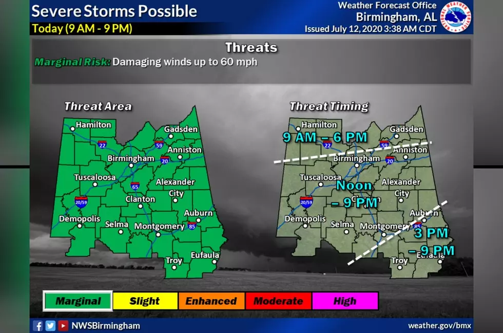
Today, Sunday, July 12, 2020, there is a Hazardous Weather Outlook issued by the National Weather Service. For today we are monitoring two different weather situations.
#1 - There is the potential for strong to severe thunderstorms between the hours of 9 am and 9 pm, with the main threat being damaging winds up to 60 mph. Also, there is a concern about heavy rains and lighting. The Storm Prediction Center has the listening areas of our Townsquare Media radio stations at a “marginal risk” level.
#2 - The heat index could reach as high 105 degrees. Please be sure you are mindful of the hot weather safety tips. They are listed below.
The Hazardous Weather Outlook is for the following counties: Marion-Lamar-Fayette-Winston-Walker-Blount-Etowah-Calhoun-Cherokee-Cleburne-Pickens-Tuscaloosa-Jefferson-Shelby-St. Clair-Talladega-Clay-Randolph-Sumter-Greene-Hale-Perry-Bibb-Chilton-Coosa-Tallapoosa - Chambers-Marengo-Dallas-Autauga-Lowndes-Elmore-Montgomery-Macon-Bullock-Lee-Russell-Pike-Barbour.
We will monitor this weather situation and will bring you updates as needed (the information will be included at the top of this story). Also, if any breaking weather news should take place, we do send out alerts through our free radio station apps. Take time out to download our app today.

(Source) For more from the National Weather Service, click here.
Hot Weather Safety Tips
Heat-Related Weather Terminology
More From Praise 93.3