T.S. Laura and Marco: Could Arrive in Rare Back-To-Back Landfalls
T.S. Laura and Marco: Could Arrive in Rare Back-To-Back Landfalls
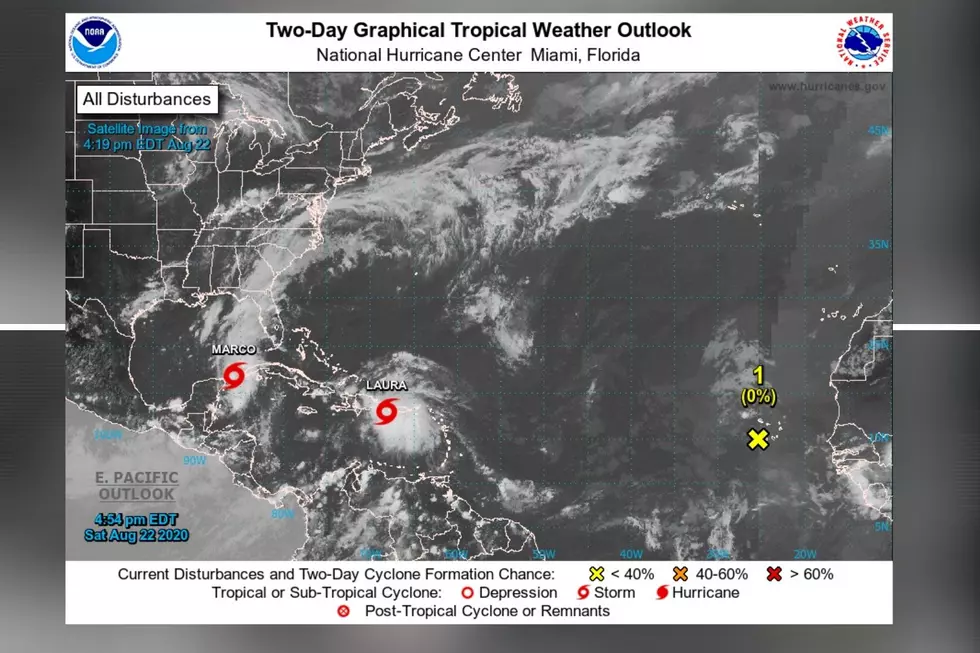
[Saturday, August 22, 2020 - evening update on Tropical Storm Laura and Marco] The situation we currently have with Tropical Storm Laura and Marco is shaping into arriving in rare back-to-back landfall. Marco will be possibly coming first on Monday and then potentially followed by Laura on Wednesday. Also, there could be some interaction between the two systems as well, but only time will tell.
As we know, tropical developments change in tracks and intensities, so here is the information we have at the time of this story.
Update on Tropical Storm Marco
- The expectation is that Marco will develop into a hurricane tonight.
- Currently entering the Gulf of Mexico.
- Marco has the potential to be a category one hurricane.
- The strength of the storm will truly determine the future of Marco’s course. (Strong – more east. Weaker – more west)
- Projected landfall will be on Monday for the Southeast Louisiana coast.
- From the Intracoastal City Louisiana eastward to the Mississippi/Alabama border, there a Hurricane Watches in place.
- From Sabine Pass eastward to the Alabama/Florida border, there is a Storm Surge Watch.
- From the Mississippi/Alabama border eastward to the Alabama/Florida border, there is a Tropical Storm Watch.
Updated on Tropical Storm Laura
- Currently bringing heavy rain to Puerto Rico.
- Over the next few days, Laura is trending to move west-northwest.
- Laura should emerge into the Gulf of Mexico by Monday.
- Laura could become a hurricane by Monday night.
- Projected landfall will be on Wednesday for the Central Louisiana coast.
I want to remind everyone that we just started the peak of Hurricane Season. That wave of greater possibility for Hurricane development lasts until the end of September. However, Hurricane season runs until November 30th.

The Colors Of The Sky
More From Praise 93.3